The first public jetty in 'Governors Bay'...
Who would know,
when wading out through squelchy mud in Sandy Bay, that there was once a jetty
right in the middle of the beach...
In December
1858 soon-to-be local resident Thomas Potts and the Provincial Engineer
Edward Dobson inspected the Dyers Bay (later Governors Bay) waterfront to
determine the site for a public jetty. They settled on ‘that portion of the
beach almost contiguous to Mr Perceval’s [sic] garden’ – what we now
know as Sandy Bay beach. In 1859 the Canterbury Provincial Council voted the
sum of £100 for the construction of the jetty, and a further £100 was
spent during 1862 to secure road access.
Westby
Percival, well known as a somewhat litigious character, put his adjacent land
on the market even before the jetty was built and was still advertising the
land well after construction.
To be sold, 23 acres of land for 10 pounds an acre cash. The above is
freehold with a frontage to the Beach and Governor's Bay Roads of more than
half a mile and adjoining the jetty at Dyer's Bay lately erected. There is
running water on the land, and bush available for firewood in the immediate
neighbourhood. (Lyttelton Times, 2 April, 1862)
However this
jetty soon proved unsatisfactory.
Governor’s Bay
Aug 18 1863
Sir
I beg to draw your attention to the state of the public jetty in
Governor’s Bay. A small sum of money expended on it now, would in all
probability prevent its destruction as at high tides the sea now washes over it
– I do not write on behalf of the Road Board more than for the inhabitants
generally and as I am not aware that any official has inspected it. I beg to
draw your attention to the subject to save future expense.
I am Sir
Your obed Sevt
Thomas H Potts
Chairman
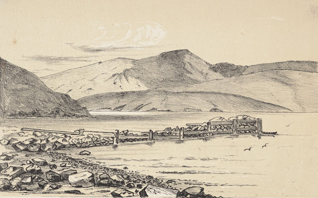
A lithograph
made by Nathaniel Wolfe and dated April 1866 shows (I think) what may be the
remains of this jetty or, more likely, the remains of an adjacent breakwater??
But I'm happy to be challenged on this.
Charles
Decimus Barraud’s 1877 painting (which was probably painted earlier since 1877
is the date of its London publication as a lithograph), View of
Lyttelton Harbour from Governor’s Bay, Banks Peninsula, clearly shows a
jetty on the beach at Sandy Bay. There are figures on the jetty and a yacht
tied up. Interestingly there is also a horse and cart and a horse and rider
making their way up the slope above Sandy Bay (I have the advantage of being
able to enlarge the image!). Even although the road is well-formed, it looks
like a long, slow haul to Lyttelton. No wonder sea transport was
favoured.
 |
| Governors Bay, Nathaniel Wolfe, 1866, Alexander Turnbull Library |
 |
| Lyttelton Harbour, Charles Decimus Barraud, 1877, Alexander Turnbull Library |


There is enough geographical detail in the lithograph to position the breakwater - which could have used the remains of the wharf - or at least the first wharf as the painting provides obvious evidence of a later construction. It is also possible that the breakwater was constructed separately on the harbour side of the wharf so one could dock easier in the prevailing easterly. As it is, the breakwater would provide a tie up of sorts on the leeward side.
ReplyDeleteI think this wharf must have gone out of use and disappeared quite quickly - but the idea of incorporating the remains of the wharf in the breakwater is really interesting and makes sense. Thanks John.
ReplyDelete